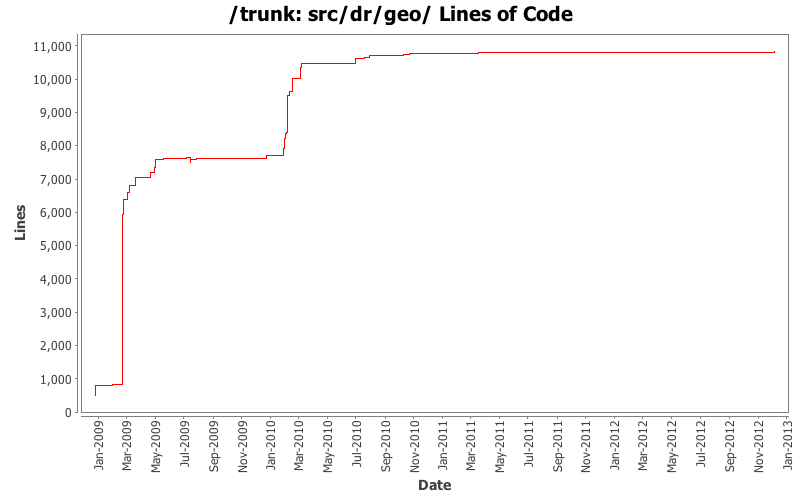
[root]/src/dr/geo
![]() cartogram
(1 files, 23 lines)
cartogram
(1 files, 23 lines)
![]() contouring
(8 files, 1612 lines)
contouring
(8 files, 1612 lines)
![]() distributions
(4 files, 92 lines)
distributions
(4 files, 92 lines)
![]() math
(3 files, 467 lines)
math
(3 files, 467 lines)
![]() operators
(2 files, 219 lines)
operators
(2 files, 219 lines)

| Author | Changes | Lines of Code | Lines per Change |
|---|---|---|---|
| Totals | 179 (100.0%) | 11688 (100.0%) | 65.2 |
| alexei.drummond | 100 (55.9%) | 9239 (79.0%) | 92.3 |
| msuchard | 43 (24.0%) | 1886 (16.1%) | 43.8 |
| philippe.lemey@gmail.com | 18 (10.1%) | 336 (2.9%) | 18.6 |
| rambaut | 14 (7.8%) | 214 (1.8%) | 15.2 |
| jheled | 1 (0.6%) | 8 (0.1%) | 8.0 |
| dong.w.xie | 3 (1.7%) | 5 (0.0%) | 1.6 |
Added transition kernel for disjoint geographic regions
30 lines of code changed in 4 files:
Extract leaf traits from the compound parameter constructed in an integrated continuous trait likelihood
14 lines of code changed in 1 file:
Tweaks to 2D KDEs.
20 lines of code changed in 2 files:
modifying KernelDensityEstimator2D constructor (that takes a gridsize argument) to set up bandwiths
1 lines of code changed in 1 file:
Made some arrays final to ensure things weren't being changed
6 lines of code changed in 1 file:
TimeSlicer update for compatibility with Google Earth 5.2
43 lines of code changed in 2 files:
added a getCentroid method in Polygon2D
21 lines of code changed in 1 file:
Switched all uses of org.virion.jam.* to jam.* (org.virion.jam.* is not being updated or fixed). This has touched alot of files but mainly just in the import statements.
6 lines of code changed in 12 files:
Updating geo-spatial regions for Gibbs sampling
92 lines of code changed in 3 files:
adding the ability to consider unions of polygons in GeoSpatialCollection
23 lines of code changed in 2 files:
adding the ability to consider unions of polygons in GeoSpatialDistribution
17 lines of code changed in 1 file:
Tool for performing KDE using a Gaussian kernel (most standard approach)
1 lines of code changed in 1 file:
deleting MultiSpatial stuff
136 lines of code changed in 5 files:
extending GeoMultiSpatialDistribution to accomodate arrays of polygons defining a region
0 lines of code changed in 1 file:
extending GeoSpatialCollectionModel to accomodate arrays of polygons in a GeoMultiSpatialDistribution defining a region
0 lines of code changed in 1 file:
Added elevation-based random walks on GTOPO30 maps
171 lines of code changed in 11 files:
Further tweaks on GTOPO30 support
118 lines of code changed in 2 files:
Added initial support for reading, tiling and coloring GTOPO30 digital elevation data
235 lines of code changed in 2 files:
random walks improvement
9 lines of code changed in 1 file:
implemented inhomogeneous random walk from KML-based lattice
355 lines of code changed in 4 files:
Use image for rendering, started consolidating viewtransform code in single class
191 lines of code changed in 5 files:
LinkedList was horrifically slow in Polygon2D for polygons of >100000 vertices. Added a general KMLViewer...
267 lines of code changed in 7 files:
Further work on geographic diffusion with boundaries
149 lines of code changed in 12 files:
Class to look at joint geographical diffusion probs
126 lines of code changed in 2 files:
Better color function for visualizing geographical transition probabilities
12 lines of code changed in 1 file:
Computing numerical transition probabilities for 2D diffusion with arbitrary well boundaries
555 lines of code changed in 12 files:
Further work on SpaceTime simulation
474 lines of code changed in 8 files:
Example reconstructs a phylogeographic path given a three taxa tree with specied end-point locations
58 lines of code changed in 2 files:
Added some cities and fixed the superclass
30 lines of code changed in 3 files:
Alexei and Marc realizing that rejection sampling in 2D map of Europe is difficult: absorptive versus reflective coastlines should give different answers.
187 lines of code changed in 5 files:
Simple stupid solution to the Italian problem.
25 lines of code changed in 2 files:
Trunk: Maintaining JDK 1.5 compatibility.
4 lines of code changed in 2 files:
Alexei and Marc adding 2-dimensional brownian bridge with rejection-sampling on map of Europe :-)
278 lines of code changed in 4 files:
Refactoring multivariate normal distribution to support nice Brownian bridge features
36 lines of code changed in 1 file:
Alexei and Marc adding N-dimensional brownian bridge with rejection-sampling!
197 lines of code changed in 5 files:
Fixed regular polygon parser
112 lines of code changed in 1 file:
DiscreteRatePriorGenerator tweaks
68 lines of code changed in 1 file:
Refactoring geo-specific functionality into dr.geo (step 1). Also, adding in shell classes for many different spatial distributions
1 lines of code changed in 2 files:
Trunk: merge from branch 1.5 in
1 lines of code changed in 1 file:
Tracer tweaks
2 lines of code changed in 1 file:
(27 more)